Tag: travel

  • A Transforming Trek to Deorital-Chandrashila

    A Transforming Trek to Deorital-Chandrashila

    Regular Office work can lead to a boredom in long run. It was a sunny winter day when I was having a discussion with one of the office colleagues to do something different as we were feeling bored due to the repetitive nature of the work in a government system. It was at this point that a thought came up to do a High Altitude trek in the Himalayas. The major reason for selecting this option was to see the ice covered mountains for the first time in our lifetime. Having decided to do a trek in Himalayas the search for the suitable trek begun. At first we decided to do a winter trek but the harsh winter in the Himalayas scared us and we decide to do a spring trek instead. Since spring is the rhododendron blooming season we started searching for a trek which has the maximum bloom of rhododendrons. The search ended at the not so famous but extremely beautiful trek known as Deorital-Chandrashila trek.

    Deorital-Chandrashila trek is a trek which is mostly known for the blooming Rhododendrons and the sighting of beautiful birds. It is also known for Tungnath Temple which is one of the five Kedars in the Himalayas. The trek is a four day Journey into the beautiful landscapes of Kedarnath Bird sanctuary and ends with the summit climb of Chandrashila peak at the final day.

    The Journey to Base Village

    Sari is the base village to the Deorital Trek. Sari is a beautiful ancient village nestled in the lap of Himalayas at around 6000 feet. The Village is located at a distance of around 240 KM from Dehradun. Since my wife was also going for the trek with me, we took a taxi to drive us to Sari Village. The drive was scenic and we stopped at the famous Devprayag-the meeting point of Alaknanda and Bhagirathi rivers. It took us around 8 hrs to reach the base village.

    Confluence of Alaknanda and Bhagirathi
    Getting Settled up at Base Village

    I had booked the trek through IndiaHikes. The hiking agency has a camp office at Sari Village. We reached the base camp at Sari at around 5:00 PM and got settled up in the tents at the IndiaHikes campus. Once we came out of our tents for the evening tea our guide showed us the first glimpse of the Chandrashila Peak. While looking at the peak it looked both beautiful and Challenging. In fact Deorital-Chandrashila is one of the few treks where the peak is visible from the base camp itself.

    View of Chandrashila peak from Sari Village

    One Good thing about the IndiaHikes is that they have a detailed plan laid out for all of their treks. The Trek leader and the support staff are well trained and supportive of any of the needs. This makes the trekking experience very pleasant and memorable.

    Day-1: Sari Village to Deoriatal Lake

    As the famous saying goes- Journey of a thousand miles begins with a single step. We started the 35 km long trek from the Sari village to reach Chandrashila peak four days later. The journey of the next four days was going to be transforming and memorable. The trek starts with steep ascent for the first 1 hour with many of the houses in the vicinity. However After about and hour the slope becomes gentle and easy on the legs. When we started our journey from the base village few of us were really beginning to think that they were not going to make it to the peak. But when you start doing any such thing you really get to know your body capabilities. After about 1 hr out bodies were quiet comfortable with the hike and we all has achieved our natural pace.

    The first campsite of this trek is truly a memorable experience. The campsite is located in the vicinity of the Deoraital Lake. This lake is popularly famous in Indian mythology because this is the place where the Yaksha Prashna episode unfolded between Yudhishthira and Yaksha (a divine nature spirit). Naturally also this alpine lake is famous for its mirror-like reflections of the Chaukhamba massif and its calm, meditative atmosphere.

    During the winter this lake gets frozen and the entire area gets covered by snow which adds to the experience of the trekker. However the most beautiful part of this place is the magical evening alongside bonfire and birdwatching. During my camping at this place I could spot many birds. If you are a bird watcher then this is the trek to do in Himalayas. The bird activity is especially high during the morning and in the month of spring.

    Day-2 Deoriatal to Syalmi via Rohini Bugyal

    This is the first long day of the trek with roughly 9 Kms to cover. We started the trek early in the morning to reach Rohini Bugyal during the lunch hour. This day is exclusively for the rhododendron lovers. The rhododendrons are found all over the trek on this day with their colours changing with the change in altitude. When you start early in the morning you can spot plenty of birds perched on the tree top sunbathing. This entire day you are trekking in Kedarnath Wildlife sanctuary and if you are lucky you can spot some wildlife too. We were lucky that we were able to spot a Himalayan Jackal just ahead of the Rohini Bugyal although I could not film it. The major highlight of this day was the rhododendrons and the lunch at the Rohini Bugyal.

    In the above pictures look for the fading colours of the rhododendrons as the height increases. This was my first encounter with these trees and it was just an amazing experience.

    Having Lunch overlooking the majestic mountains was an all together a different experience.

    The sunset at the Shyalmi campsite was just amazing. Watching sunset high up in the mountains far away from the civilisation is just a different experience all together.

    However my most unique experience of the day was the Shepherd houses. I was seeing them for the first time. These houses are simple lacking any kind of amenities. Shepherds live here when they come to stay here during the dummers. If you are lucky and the sky in cloud less you can do stargazing in the night. This campsite is an excellent place for stargazing. However we were little unlucky, it was cloudy that day.

    Day-3 Syalmi to Baniyakund

    The distance of this day is approximately 6.5 km and it takes 4 to 5 hour to cover this distance by walk. This day is fully dedicated to forest walk and feeling the nature around us. The day is not very difficult neither it is very easy. We started our trek at 9 AM in the morning to reach the Baniya-Kund Campsite around 3 PM. The forest section on this day is thick and majestic. If you are trekking peacefully you can hear the sound of the forest. We could hear the sound of many of the birds during the morning time of our trek.

    A beautiful experience of this day is that you trek along the river stream. The sound of water is with you throughout the day of your trek which is a different experience all together. The Baniyakund campsite is located at location which is quite touristy. If you are a snow lover it quite definite that you will find snow at this campsite even in March and April as well.

    Day-4 Summit Day

    This was the longest, hardest and most rewarding day of the trek. The summit push starts at 3 am in the morning. However in my opinion it starts way before that in your mind. The summit of Deorital Trek is one of the most beautiful summit. You get to see 360 degree view of the Himalayan peaks from the Chandrashila peak which itself is a 4200 meter peak. At the start of the this day trek we started from the campsite to reach the starting point of Tungnath Temple trek at about 5 am. From here the actual trek starts. If you trekking in winter and spring you will encounter huge snow in this area. The snowcapped meadows are one of the most beautiful landscape which you will encounter on this trek.

    Since I started early in the morning the view of sunrise from this meadow was a mesmerizing experience. The sunrise looks so good that it takes away all the discomfort of waking up at 3 am in the morning.

    This day holds another treasure for wildlife lovers. The colourful state bird of Uttarakhand Monal is especially found in this area. I was lucky enough to spot a pair of Monal on this route in the morning although I could not film it.

    Darshan of Tungnath, the highest Shiva temple in the world was a divine experience. Although the temple was closed and filled with snow we did the Darshan from outside. This temple is one of the Panch Kedars and thousands of devotees visit this temple every year.

    The Chandrashila Peak is located at a distance of 1 km from Tungnath and it takes around 1 hrs to reach the Chandrashila peak from Tungnath.

    During my trek due to turn around time I could not reach the Chandrashila peak however everyone who reached the peak was mesmerized by the beauty of the Himalayas.

    The concept of trekking in modern terms is new in India. However during the ancient period this was very much prevalent in our country. Monks used to go in the Jungles to do ‘Tapasya’.

    Deoriatal was my first multi day trek and it was really memorable. The harsh conditions of the mountains made me appreciate whatever I have in my life and the much needed disconnect from the modern world gave me some time to think about myself. Overall it was truly a transforming experience.

  • A Quiet Stay at Kathi(Satara)

    A Quiet Stay at Kathi(Satara)

    There are places that don’t ask anything from you.
    They don’t demand productivity, urgency, or performance.
    Kathi is one such village.

    Tucked quietly in the folds of the Sahyadris in Satara district, Kathi does not announce itself. There are no landmarks shouting for attention, no itineraries to tick off. What it offers instead is far rarer — a life that unfolds without hurry.

    Indian Cities are increasingly becoming congested and overcrowded. Finding a peaceful moment in the cities is becoming a luxury now. Pune City has been particularly heavily polluted this year with AQI reaching to 400. It was in this frame of mind that I decided to take some time out and stay at a quiet place outside the city. My search ended at a Quiet Villa named as Red Stone Villa by Koyna stays located in a small village named Kathi in Satara district of Maharashtra. Most of the population in this village is involved in agriculture. However with the coming up of tourism a small population is now being involved in hospitality and the land use and occupation change is now visible here.

    When I reached this Kathi village I was amazed with the rustic beauty and old world charm of this village. The village lies at a hill plateau overlooking the Shivsagar Dam built on Koyna River. The natural setting of the place is amazing.

    The Village is still far away from what we call ‘Development’ in modern terms. There are no modern cafes and restaurants. People are simple and welcoming. This makes this place perfect for Eco-tourism and many eco tourism resorts are now opening in this village. This village is perfect place for spending quiet days. During my stay at this place I was reminded of the the Dak-Bunglows of British times. Britishers used to built Dak-Bunglow at places which were far from modern world and having plenty of nature around. This gave them the time to think and innovate.

    Relaxing Activities In Kathi

    The village of Kathi is located at a place which is called Oxygen valley. This is because of strong winds that blow here throughout the day. The wind is so strong here that the largest Windmill farm in Asia is located near this village. You can just sit and feel the air in your lungs.

    Wind Mill farm

    Visit to the nearest Windmill farm is a great experience here. The road from Kathi to Satara passes through this wind mill farm and there is one spot where the road is straight over the plateau. This is a perfect place to take an evening walk. I took a walk on this road one evening and it felt magical.

    K-2 Point

    When it comes to viewing sunset in the Western Ghats I found that K-2 point offers one of the most mesmerising view. The place is located at the highest point in the region overlooking the Koyna Backwaters. The view of the sunset from here is just amazing. The only catch is that due to excessive fog at times it becomes difficult to view the sunset. What I found most beautiful is that this place has no crowd at all and hence you can enjoy the beautiful sunset in peace. However despite its natural beauty what disturbed me here was that people have thrown beer bottles and water bottles which was acting as a thorn in the beauty of this place. Seeing this one can sense how much civic sense Indians lack.

    Dhareshwar Shiv Mandir

    Perhaps one of the most unique temples in India that I have visited this Shiva temple is nestled into deep forest and on the edge of a mountain overlooking a huge valley. The main shrine is in a rock-cut cave traditionally associated with Shri Ram’s era, housing a temple to Shri Ram along with a sacred Shiva shrine (Shivshambu Mahadev) regarded as a teerthakshetra. This place is a great nature spot and there is an all weather active waterfall here. When I visited this temple I found that to be crowd free and full of peace and tranquility. This place is great for meditation and Dhyan and one can sit for some time here to connect with spirituality. The active waterfall of this place is considered sacred and the locals use the water for different religious purposes.

    This place is a heaven for star gazers as this place still has not been heavily polluted by light pollution. During the night time star gazing is a great activity here. During our visit we sat in the night sky and all the night stars were visible to us. Using the apps like night sky enhances the experience of Star Gazing by displaying the positions of the stars in the sky.

    Kathi Village has everything that a slow life asks for. A lakeside location, spiritual places nearby and a great sunset view point to go and sit during the evening. Places like these are a modern day luxury for us when the “modernisation and cafe culture” is reaching in every nooks and corners of the country. The very nature of the modern lifestyle is stress-full and few days spent at places like these adds much needed value to our quality of life.

  • Photographing Balck Kite (Milvus migrans) In Pune

    Photographing Balck Kite (Milvus migrans) In Pune

    Spotting birds in Indian Cityscape is becoming a rarity now. The cities in India are slowly becoming urban jungles with no space for trees and wildlife. The birds which are frequently visible in the countryside are no where to be found in the cities. However when I spotted this beautiful big birds in my colony I was surprised to see that they are not even surviving but flourishing in the cityscape. Upon enquiring I came to know that this bird was named as Balck Kite (Milvus migrans). The subspecies of this bird M. M. Govinda also known as the small Indian kite or formerly Pariah Kite is found across the Indian cities and their population is thriving in the Indian cities due to their flexible dietary habits.

    Black Kite is a raptor species which means they hunt and eat other animals and have special adaptations for catching and consuming prey. Raptors are also called birds of prey and include eagles, hawks, kites, falcons, owls, and most vultures.

    Black kites inhabit most Indian states, from the Indo-Gangetic plains to Himalayan foothills and northeastern regions, including Delhi, Maharashtra, Karnataka, and Rajasthan. However what I was most curious about was the astonishingly high number of population of these species in PMC area nearby Mula- Mutha river. The major reason for their high density in this area seems to be because of abundance of urban waste from households, markets, and slaughterhouses. This area also provides constant scavenging opportunities, drawing kites to riversides and dumps. Proximity to PMC headquarters along the Mula-Mutha River supports foraging on scraps and small prey like fish or pigeons.

    Studying the changing behaviour of these species shows that species too have the ability to adopt to the changing environment. Also those species are likely to survive more who can adopt to the changing landscape better in a better way. Having these species nearby gives me an excellent opportunity to photograph them and test my photography skills!

  • Daund-Manmad Railway: Social and Economic Changes in Maharashtra

    The construction and operation of the Daund-Manmad Railway line during the British colonial period (1878-1947) fundamentally transformed the social and economic landscape of Maharashtra and neighboring regions. This strategic “chord line” connecting the Great Indian Peninsula Railway’s southeastern and northeastern divisions catalyzed unprecedented changes in demographics, commerce, agriculture, and social structures across the Deccan plateau.

    Demographic and Migration Patterns

    Large-Scale Population Movement

    The Daund-Manmad Railway triggered substantial demographic shifts throughout the region, fundamentally altering settlement patterns and population distribution. The railway construction phase (1875-1880) attracted thousands of migrant workers from across Maharashtra, Gujarat, Madhya Pradesh, and other regions of British India. This initial wave of construction-related migration established permanent settlement patterns that persisted throughout the colonial period.

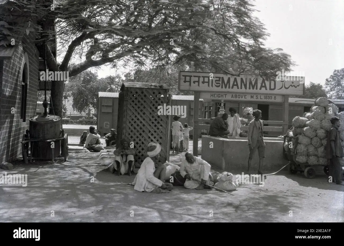
    Rural-to-urban migration accelerated dramatically after the railway’s completion in 1878. Daund emerged as a major railway junction, transforming from a small agricultural town into a significant urban center. The town’s population expanded exponentially as it became a hub for more than 125 coal engines and their associated workforce. Even today a new Electric Loco shed has been established which shows the importance of Daund as a railway town. Similarly, Manmad developed into a crucial junction connecting British territories with the Nizam’s Guaranteed State Railway, facilitating movement between the princely state of Hyderabad and colonial Maharashtra.

    The railway facilitated seasonal migration patterns linked to agricultural cycles and railway maintenance schedules. During construction and later expansion phases, temporary labor camps housed thousands of workers who later established permanent communities along the railway corridor. These migration patterns created lasting demographic changes, with railway towns becoming cosmopolitan centers housing diverse linguistic, religious, and caste communities.

    Inter-Regional Connectivity and Social Integration

    The improved connectivity facilitated inter-regional marriage alliances and social relationships that had been previously constrained by distance and transportation difficulties. The railway enabled regular communication and travel between communities across the Deccan, gradually breaking down regional isolation that had characterized rural Maharashtra for centuries.

    Census data from the colonial period indicates that immigration to railway towns significantly exceeded natural population growth. In Daund, the establishment of railway facilities created a receiver station of the Imperial Wireless Chain and military camps during World War II, further attracting diverse populations and enhancing the town’s strategic importance.

    Economic Transformation

    Agricultural Commercialization and Market Integration

    The Daund-Manmad Railway fundamentally altered agricultural practices and market relationships across the corridor region. The railway reduced transportation costs by an estimated 15-20% between northern and southern India, making previously unprofitable agricultural exports economically viable.

    Cotton cultivation expanded dramatically in areas with railway access, as farmers could now transport their produce efficiently to Bombay’s cotton markets and processing facilities. This shift from subsistence to commercial agriculture increased cash crop cultivation by an estimated 25-40% in the railway corridor. The integration with Bombay’s cotton export trade generated approximately Rs. 5-10 million annually in additional trade value during peak periods.

    The railway also facilitated the development of truck farming and market gardening to supply urban centers with perishable goods. Farmers near railway stations could now transport fruits, vegetables, and dairy products to distant urban markets, increasing perishable trade by approximately 50%.

    Industrial Development and Manufacturing

    The railway corridor witnessed significant industrial development, particularly in sectors related to railway operations and agricultural processing. Cotton processing facilities were established along the route to take advantage of improved transportation access to both raw materials and export markets. The estimated investment in these facilities reached Rs. 1-2 million during the peak development period.

    A unique industrial development emerged from railway operations themselves- brick manufacturing using coal ash from steam locomotives. The abundance of coal ash from Daund’s locomotive shed, which housed more than 125 coal engines, created a thriving brick-making industry that supplied construction materials to major cities across India. This industry generated approximately Rs. 500,000 in annual economic activity and provided employment for hundreds of workers.

    Railway workshop and maintenance facilities developed at major stations, creating specialized industrial employment and technical skills training. These workshops required significant capital investment (estimated at Rs. 200,000) and employed skilled craftsmen, engineers, and mechanics.

    Decline of Traditional Industries

    The improved transportation connectivity had devastating effects on traditional handicraft industries. Cheaper British manufactured goods could now reach previously isolated markets more efficiently, leading to a 40-60% decline in traditional handicraft production. This industrial displacement forced thousands of traditional artisans to seek alternative employment in railway-related industries or migrate to urban centers.

    Employment and Labor Market Changes

    Direct Railway Employment

    The Daund-Manmad Railway created approximately 2,000 direct employment positions in various categories including engineers, station masters, signalmen, guards, drivers, firemen, and maintenance workers. These positions provided annual wages totaling approximately Rs. 150,000, representing a significant injection of steady income into the local economy.

    The railway employment offered unprecedented social mobility for individuals from lower castes and disadvantaged backgrounds. Railway jobs provided regular salaries, standardized working conditions, and opportunities for advancement that were largely absent in traditional occupations. This employment transformation contributed to the breakdown of rigid caste-based occupational restrictions. This has been perhaps one of the most important impact of Railways in the long term.

    Ancillary Service Industries

    Railway operations stimulated the development of extensive ancillary service industries generating approximately Rs. 300,000 in annual economic activity. These included:

    • Hotels and lodging facilities for railway passengers and traveling merchants
    • Food vendors and catering services at railway stations
    • Transportation services connecting railway stations to surrounding towns and villages
    • Trading and commercial establishments facilitating goods movement
    • Banking and financial services supporting increased commercial activity

    Women’s Employment Opportunities

    The railway system created new employment opportunities for women, particularly in roles as vendors, cleaners, and service providers at railway stations. While these positions were often informal and poorly paid, they represented some of the first opportunities for women to engage in regular wage labor outside traditional household occupations.

    Social Structure and Community Development

    Emergence of Railway Communities

    The establishment of railway operations led to the formation of distinct railway worker communities with their own social institutions, recreational facilities, and collective identity. Railway colonies with standardized housing were constructed at major stations, creating planned residential areas that contrasted sharply with traditional village layouts.

    These railway communities developed cooperative societies, worker unions, and social organizations that provided mutual support and collective bargaining power. The railway workers also established recreational clubs and educational institutions that served not only railway families but also the broader community. The building of community hall and clubs in the colonies made increased social interaction possible leading to increased flow of modern ideas. The two British era community halls in Daund stands testament to this fact even today.

    Cultural Integration and Social Change

    The railway facilitated increased interaction between different linguistic and religious communities, promoting cultural exchange and social integration across previously isolated regions. The standardization of railway time introduced modern temporal concepts to rural areas, gradually replacing traditional time-keeping methods based on agricultural and religious cycles.

    The railway’s connection between British territories and the Nizam’s state at Manmad facilitated integration of princely state populations with colonial administrative and commercial systems. This integration accelerated the adoption of British administrative practices and commercial relationships across political boundaries.

    Educational and Health Infrastructure

    Railway towns witnessed significant investment in educational institutions to serve the growing populations and meet the literacy requirements of railway operations. These schools often provided education in multiple languages to accommodate the diverse communities attracted to railway employment.

    Healthcare facilities improved substantially in railway towns, as the colonial administration recognized the importance of maintaining healthy railway workers and their families. Railway dispensaries and hospitals provided modern medical care that was often unavailable in traditional rural areas.

    Regional Economic Integration

    Trade Route Optimization

    The Daund-Manmad Railway created a crucial transportation corridor that reduced the need for lengthy detours through Bombay for trade between northern and southern India. This optimization reduced transportation costs and time, making previously unprofitable trade routes economically viable.

    The railway facilitated integration between grain surplus and deficit regions, enabling efficient food distribution during normal periods and famine relief during crises. Although the impact of railways in reducing famines is debatable. The enhanced connectivity allowed grain traders to arbitrage price differences between regions, generally reducing price volatility and improving food security.

    Financial and Investment Impact

    The British colonial government invested approximately £800,000 (Rs. 1.2 crore in 1878 values) in the construction of the Daund-Manmad Railway. This substantial capital investment had significant multiplier effects throughout the regional economy, creating employment during construction and establishing permanent infrastructure that facilitated ongoing economic activity.

    The railway enhanced tax revenue collection for the colonial administration by approximately Rs. 200,000 annually through increased trade, property values, and economic activity. This revenue enhancement helped justify continued investment in railway infrastructure expansion.

    Banking and credit facilities developed in railway towns to support the increased commercial activity, with an estimated Rs. 50,000 in new financial capital establishment. These facilities provided credit for traders, farmers, and small entrepreneurs seeking to capitalize on improved transportation access.

    Long-term Developmental Consequences

    Urban Development Patterns

    The railway established urban development patterns that persist to the present day. Daund and Manmad evolved into permanent transportation and commercial centers whose economic importance transcended the colonial period. The modern doubling project worth Rs. 2,081.27 crores approved in 2017 demonstrates the continuing strategic importance of this British-era transportation corridor. As of today the doubling is about to get completed from Daund to Manmad.

    Social Legacy

    The social changes initiated by the railway had lasting effects on caste relations, occupational mobility, and community structures throughout the region. The breakdown of traditional occupational restrictions and the emergence of merit-based railway employment contributed to gradual social modernization that accelerated after independence.

    The cosmopolitan communities that developed in railway towns created lasting traditions of linguistic and religious diversity that continue to characterize these areas. The educational and healthcare infrastructure established during the railway period provided foundations for continued development in the post-independence era.

    The social and economic impact of the Daund-Manmad Railway during the British period was transformative and far-reaching, extending well beyond the immediate transportation benefits to fundamentally reshape demographic patterns, economic structures, and social relationships across the Deccan plateau. The railway catalyzed rural-to-urban migration, agricultural commercialization, industrial development, and social modernization while simultaneously contributing to the decline of traditional industries and social structures.

    The economic benefits, including reduced transportation costs, market integration, and new employment opportunities, generated substantial wealth creation estimated at over Rs. 10 million annually in direct and indirect economic activity. However, these benefits were accompanied by social disruption, including the displacement of traditional artisans and the challenges of rapid urbanization.

    The railway’s role in facilitating integration between British territories and princely states, particularly through the Manmad connection to Hyderabad, demonstrated its broader strategic importance in colonial administration and economic policy. The infrastructure and social changes initiated during this period established foundations that continue to influence regional development patterns, as evidenced by the ongoing significance of the Daund- Manmad corridor in contemporary Indian transportation planning.

  • Chasing Chinkara(Indian Gazelle) Inside Mayureshwar Wildlife Sanctuary!

    Chasing Chinkara(Indian Gazelle) Inside Mayureshwar Wildlife Sanctuary!

    Mayureshwar Wildlife sanctuary is comparatively lesser known but very unique wildlife sanctuary located at a distance of about 75 km from Pune city. The sanctuary is so less popular that when I visited the sanctuary even the google map could not identify the exact location of the sanctuary. I had to take the help of a forest department official to find out the exact location of the sanctuary. However if you really want to learn photography this is the place to go. With comparatively less crowd and wildlife density one can learn the concept of composition and also learn to have patience which is a very important skill in wildlife photography.

    Mayureshwar wildlife sanctuary is unique in the sense that this is probably the only wildlife sanctuary in India where you can take your own vehicle inside the sanctuary for safari purpose. Walking inside the sanctuary is also permitted so one can take a walk in the sanctuary and spot various kind of birds from up close. There is a dedicated watch tower inside the sanctuary from where one can get a birds eye view of the surroundings. However the only menace inside the sanctuary are street dogs. You can find them in good numbers in the sanctuary roaming around and they can be very scary.

    The sanctuary is dominated by semi arid grasslands and dry deciduous scrub forests. Acacia catechu (Khair), Dalbergia latifolia (Sissoo), and Ziziphus mauritiana (Ber) are the primary tree species found in the sanctuary. These trees are interspersed with grasslands. This makes spotting the wildlife very easy inside the sanctuary.

    The sanctuary is famous for Indian gazelle (Chinkara) who are found here in herds. However if you are lucky then you can also spot Indian gray wolf, striped hyena, Indian fox, jackal, and Hares. During my visit to the sanctuary I was able to spot a big herd of Chinkara running across the sanctuary however I could not properly photograph it.

    The sanctuary is also famous for many different kinds of birds. The bird species include Indian roller, short-toed snake eagle, Bonelli’s eagle, and Grey Francolin. There are certain winter visitors also like European Roller and Montagu’s Harrier.

    Population pressure on nature is rising day be day in India. However these small efforts to create the sanctuaries for preserving the population of certain species gives us hope that our future generations will be above to see these species in wild.

    The best time to visit the sanctuary is from November to March as the weather is pleasant at this time. I visited the sanctuary in the month of September which was probably not the best of times. The Forest department has a small guest house also at the starting gate of the sanctuary. One can stay there if he wants to spend a peaceful night in the nature not for away from Pune. The morning and Evening walk inside the sanctuary feels really refreshing.

  • History and Development of Dhond-Manmad State Railway

    History and Development of Dhond-Manmad State Railway

    The development of Railway system in India followed a very haphazard and complex pattern. Some of the Railways were owned by the companies others were owned by stated railways. There were a few others which were owned by the state itself due to their strategic importance. The Dhond-Manmad Railway was one such strategically important chord line railway whose construction was done under the direct government supervision.

    The Daund-Manmad Railway (originally known as the Dhond-Manmad State Railway) represents one of the most strategically important “chord lines” constructed during the British colonial period in India. This railway line served as a crucial connecting link between two major divisions of the Great Indian Peninsula Railway (GIPR) and played a vital role in facilitating efficient transportation across the Indian subcontinent.

    Background and Strategic Importance

    The Dhond-Manmad State Railway was conceived as a strategic “chord line” designed to connect the Great Indian Peninsula Railway’s (GIPR) south-eastern main line to Madras with the GIPR north-eastern main line to Allahabad. This connection eliminated the need for trains traveling between these two major routes to make lengthy detours through Bombay (Mumbai), significantly reducing travel time and operational costs.

    The railway was a broad gauge (BG) line measuring 145 miles (197 kilometers) in total length, connecting Manmad Junction, located 162 miles (260 kilometers) from Bombay on the north-east section, with Dhond (present-day Daund) in Poona (Pune), situated 167 miles (267 kilometers) from Bombay on the south-east section.

    Construction and Opening

    Timeline and Development

    The construction of the Dhond-Manmad State Railway began in the mid-1870s under direct government supervision. The line was officially opened for traffic on April 17, 1878. However, the construction faced significant engineering challenges, particularly in the construction of major bridges and infrastructure across the challenging terrain of Maharashtra.

    Some of the large bridges which were begun in 1879 were not completed until after the rains of 1880. This indicates that the initial opening of the line was for basic operations, while major infrastructure projects continued for several years after the official inauguration.

    Administrative Management

    Up to the end of 1880, the line was managed directly by the Government of India. This direct government control during the initial operational period was typical for strategically important railway lines that required careful oversight and standardization. In 1881, management was transferred to the Great Indian Peninsula Railway (GIPR), and the line became an integral part of the GIPR South East Division.

    Engineering Personnel and Administration

    Key Personnel During Construction

    The construction and early operation of the Dhond-Manmad State Railway involved several distinguished British engineers and administrators from the Public Works Department and Railway Branch:

    Chief Engineers and Senior Officials:

    • Alexander Izat served as Chief Engineer, on loan from the Public Works Department (PWD) circa 1878wiki.fibis
    • James Rhind worked as Assistant to Alexander Izat during 1878-1880wiki.fibis
    • Thomas Freeman Dowden, Colonel R.E. was appointed as the first Manager of the Dhond-Manmad State Railway during 1878-1879wiki.fibis
    • Captain W.J. Engledue served as Acting Manager of the Dhond and Manmad State Railway in 1880 and represented the railway as a delegate at the Railway Conferencewiki.fibis

    Assistant Engineers:

    • Ernest Ifill Shadbolt from the Public Works Department was posted as Assistant Engineer to the Dhond-Manmad State Railway during the period 1874-1883wiki.fibis
    • Trevredyn Rashleigh Wynne was deployed from the Railway Branch of the Public Works Department as Assistant Engineer from 1877-1879wiki.fibis
    • John Edwin Dallas, also from the Railway Branch, was posted between 1876 and 1881 to the Dhond-Manmad State Railway specifically for “setting out and construction” activitieswiki.fibis

    These appointments demonstrate the high priority given to this project by the colonial administration, with experienced engineers from various departments being seconded to ensure successful completion of this strategically important line.

    Operational Significance During British Era

    Strategic Military and Administrative Role

    The Daund-Manmad Railway served crucial military and administrative functions for the British colonial government. The line provided a direct connection between the northern and southern railway networks, facilitating rapid troop movements and efficient transportation of military supplies and equipment across the Deccan plateau.pib+1

    The strategic importance of this route became particularly evident during World War I and World War II, when the railway served as a vital logistics corridor for British military operations. The connection to Ahmednagar, which housed a major tank base of the Southern Command, Indian Army, made this railway line essential for defense communications.pib+1

    Commercial and Economic Impact

    During the British period, Daund emerged as a significant railway town and junction. The establishment of the railway brought substantial infrastructure development to the region:bharatpedia+1

    Locomotive and Engineering Facilities:

    • Daund became an important center for coal engines during the British period, with more than 125 coal engines stationed at the locomotive shedbharatpedia
    • The abundance of coal ash from these engines led to the development of a thriving brick-making industry, with bricks being transported to various major cities across Indiabharatpedia
    • A receiver station of the Imperial Wireless Chain was installed three kilometers outside Daund, demonstrating the town’s growing importance in British communication networks.

    Infrastructure Development:

    • Staff quarters were constructed at Dhond, Lonavala, Manmad, and Igatpuri between 1885-1890 to house the growing railway workforceindianrailways
    • The railway facilitated the construction of the bridge over the Bhima River in 1928, connecting Daund to Srigonda and expanding regional connectivitywikipedia+1
    • Military camps were established in Daund from 1942 to 1945, highlighting the strategic importance of the railway junction during World War IIwikipedia+1

    Integration with GIPR Network

    As part of the GIPR South East Division, the Dhond-Manmad State Railway became integral to the broader railway network connecting Bombay with Calcutta and Madras. The line served as a crucial chord that allowed trains to bypass the congested Bombay terminal, providing alternative routes for both passenger and freight traffic.wiki.fibis+1

    The railway facilitated connections with several other important lines:

    • Connection to the GIPR north-eastern main line toward Jubbulpore and eventually Calcuttawiki.fibis
    • Link to the GIPR south-eastern main line toward Raichur and Madraswiki.fibis
    • Integration with the Nizam’s Guaranteed State Railway at Manmad, providing connections to Hyderabad and the Deccan regionwikipedia+2

    Technical and Engineering Achievements

    Bridge Construction and Engineering Challenges

    The construction of the Dhond-Manmad State Railway required significant engineering expertise, particularly for the major bridges constructed between 1879-1880. These bridges were essential for crossing the numerous rivers and challenging terrain between Daund and Manmad, including crossings over tributaries of the Godavari and Bhima river systems.wiki.fibis

    The completion of these bridges after the 1880 monsoon rains indicates the challenges faced in construction during the monsoon season, when river levels would have been at their highest and construction work most difficult.wiki.fibis

    Gauge Standardization

    The adoption of broad gauge (5 feet 6 inches) for the Dhond-Manmad State Railway was consistent with the GIPR’s commitment to creating a unified, high-capacity railway network. This gauge choice facilitated seamless integration with both the north-eastern and south-eastern divisions of the GIPR, allowing for through running of trains without gauge changes.

    Legacy and Historical Impact

    Foundation for Modern Connectivity

    The Dhond-Manmad State Railway laid the foundation for what remains today one of India’s most important railway corridors. The current Daund-Manmad line continues to serve as a crucial link between northern and southern India, carrying substantial passenger and freight traffic.

    Recent developments demonstrate the enduring importance of this British-era railway:

    • A doubling project worth Rs. 2,081.27 crores was approved in 2017 to enhance capacity on this historic route.
    • By 2023, over 120 kilometers (50.83%) of the doubling work had been completed, with 65% overall physical progress achieved.
    • The route now handles approximately 98 trains daily, serving over 70,000 passengers and substantial freight traffic.
    • The line which was operated by the Solapur Division of Central Railways has been transferred to Pune Division with effect from 1/04/24.

    Integration with Princely States

    The strategic location of Manmad as the terminus of the Dhond-Manmad State Railway made it a crucial junction for connections with the Nizam’s Guaranteed State Railway (metre-gauge) until 1948. This interconnection facilitated trade and passenger movement between British India and the princely state of Hyderabad, demonstrating the railway’s role in integrating the diverse political entities of colonial India.wikipedia+1

    Conclusion

    The Daund-Manmad Railway during the British era represents a remarkable achievement in colonial railway engineering and strategic planning. Conceived as a chord line to enhance connectivity between major GIPR divisions, it evolved into a vital transportation artery that served military, commercial, and administrative needs of the British Empire in India.

    The railway’s construction involved some of the most experienced British engineers of the period, and its completion in 1878 marked a significant milestone in India’s railway development. The line’s integration into the GIPR South East Division ensured its role in the broader network connecting Bombay with Calcutta and Madras, while its connection with the Nizam’s railway at Manmad facilitated integration with princely state territories.

    The infrastructure development that accompanied the railway’s establishment—including locomotive sheds, staff quarters, communication facilities, and industrial development—transformed Daund from a small town into an important railway junction that continues to play a crucial role in India’s transportation network today. The ongoing doubling project and continued heavy usage of this route underscore the prescient strategic planning of the British railway engineers who conceived and constructed this vital link over 145 years ago.

  • A visit to Yedshi Ramling Ghat Wildlife Sanctuary

    A visit to Yedshi Ramling Ghat Wildlife Sanctuary

    Yedshi Ramling Ghat Wildlife Sanctuary is a protected area located in the Osmanabad district of Maharashtra, India. Established on May 23, 1997, the sanctuary spans approximately 22.38 square kilometers and is managed by the Maharashtra State Forest Department. It is situated in the villages of Yedshi, Wadgaon, and Bhanasgaon within the Kalamb Tehsil. The sanctuary lies in the Balaghat mountain range of the Sahyadri hills, about 20 km from Osmanabad city and 95 km from Beed.

    Flora and Fauna

    The sanctuary features South Deccan Plateau dry deciduous forests and thorny scrublands. Common tree species include teak (Tectona grandis), sandalwood (Santalum album), neem (Azadirachta indica), and various Acacia species. Shrubs like Lantana camara and Carissa carandas are also prevalent.

    Wildlife in the sanctuary includes leopards, sloth bears, blackbucks, jackals, wolves, foxes, monitor lizards, porcupines, barking deer, and hares. Over 100 bird species have been recorded, making it a notable spot for birdwatching.

    A significant attraction within the sanctuary is the ancient Ramling Temple dedicated to Lord Shiva. Nearby, there’s a waterfall and a cave associated with local legends involving figures from the Ramayana, such as Ravana and Jatayu. These sites add cultural and mythological significance to the natural beauty of the area.

    Since a long time I had a fascination for visiting the Yedshi Ramling Ghat Sanctuary. This was mainly because the sanctuary used to be the starting point of now defunct Barsi Light Railway and a mejestic railway rest house is located inside the sanctuary. Since long I had this fascination for studying about the heritage railways. So I wanted to go to this place to see the now defunct basri Light Railways and appreciate the Railway Heritage. However once I reached there I could appreciate the true beauty of the place. The largely undisturbed wildlife sanctuary is a beautiful sight to see the bird and occasionally spot a few animals also.

    The place located in Osmanabad district of Maharashtra is appreciated for its natural beauty specially during the rainy season. When I visited the sanctuary, there was a scare of Tiger being roaming inside the sanctuary. During our evening walk we could hear the roar of the tiger although it was far away from us, but still it was scary. However the real thrill was spotting the beautiful birds in the sanctuary and shooting them with my camera. We had a beautiful quiet evening inside the sanctuary in the Railway Rest house and it was indeed a thrilling experience.
  • Capturing Sunset at Pawna Lake !

    Capturing Sunset at Pawna Lake !

    Pawna Lake is one of the most famous spots near Pune to enjoy an evening or do camping with friends and your loved ones. One Such day we decided to visit the lake to enjoy a sunset. The views of the sunset were truly amazing and place indeed looked magical in the evening. Certainly Pawna lake is one of the best spots to enjoy sunset near Pune.

    Pawna Lake is one of the best places to enjoy an evening. However the place is slowly becoming crowded due to more influx of visitors especially during the weekends. I would recommend visiting the place since the views are worth it.

  • Unveiling Orchha: A Journey Into Bundela Dynasty’s Legacy!

    Unveiling Orchha: A Journey Into Bundela Dynasty’s Legacy!

    India is a land of great cultural and religious diversity. The country is home to many of the ancient town and cities which give us a glimpse into the history and lifestyle of the past. Orchha is a small town in the central Indian state of Madhya Pradesh. It is a hidden gem that offers a captivating glimpse into India’s rich history and architecture. Located on the banks of the Betwa River, Orchha is known for its stunning palaces. The town also has intricately designed temples and well-preserved forts. These structures transport visitors back to the era of the Bundela kings who once ruled this region.

    View of Orchha Town

    Orchha has a rich and fascinating history that dates back to the early 16th century. It was founded in 1501 AD by Rudra Pratap Singh. He was a Bundela Rajput chief and the first ruler of Orchha. The town served as the capital of the Bundela dynasty for several centuries. Under their rule, Orchha flourished. It became a significant cultural and architectural center.

    Key Historical Periods in Orchha

    1. Foundation and Early Development (16th Century)

    • Rudra Pratap Singh, the founder of Orchha, established the town on the banks of the Betwa River. He strategically chose the location for its natural defense advantages. He began the construction of the Orchha Fort. He laid the foundations for what would become a powerful and culturally vibrant kingdom.
    • The Bundela rulers, over time, constructed a series of palaces, temples, and other structures that reflected their wealth and power. Orchha quickly became known for its unique blend of Rajput and Mughal architecture.

    2. Raja Bir Singh Deo’s Reign (1605-1627)

    • One of the most notable rulers of Orchha, Raja Bir Singh Deo, is credited with bringing Orchha to its zenith. Bir Singh Deo was a contemporary and ally of the Mughal emperor Jahangir. He is known for his military prowess and architectural contributions.
    • He constructed several magnificent structures in Orchha. These include the Jahangir Mahal, built to commemorate Emperor Jahangir’s visit to Orchha, and the Chaturbhuj Temple. His reign marked a period of prosperity and cultural development, making Orchha a prominent regional power.

    3. Mughal Influence and Conflicts (17th Century):

    • The relationship between the Bundela rulers and the Mughal Empire was complex, marked by periods of alliance and conflict. While Bir Singh Deo enjoyed a close relationship with Jahangir, later rulers faced challenges from the Mughals.
    • Madhukar Shah, the father of Bir Singh Deo, had a tumultuous relationship with the Mughal emperor Akbar, leading to conflicts that affected Orchha’s political stability. Despite this, the Bundelas managed to maintain their autonomy for a significant period.

    4. Decline and Maratha Influence (18th Century):

    • The 18th century saw the decline of Orchha’s power as the Mughal Empire weakened and the Marathas began to expand their influence in central India. Orchha, like many other Rajput states, struggled to maintain its independence in the face of growing Maratha power.
    • During this period, Orchha’s political significance diminished, and the town gradually lost its status as a major regional center. However, the Bundela rulers continued to patronize arts and architecture, leading to the construction of more temples and palaces.

    5. British Colonial Period and Post-Independence:

    • In the 19th century, Orchha came under British suzerainty, and the town’s significance further declined. However, the Bundela rulers retained their titles and continued to play a role in local governance under British rule.
    • After India’s independence in 1947, Orchha became part of the state of Madhya Pradesh. However, the town has since become a significant tourist destination. Its historical and cultural heritage attracts visitors interested in its history and architecture.

    Key Attractions in Orchha

    Orchha Fort Complex:

    • The heart of the town, this complex houses several historical buildings. The Jahangir Mahal is a highlight, with its impressive Indo-Islamic architecture and panoramic views of the surrounding landscape.
    • Raja Mahal, another palace within the fort, is famous for its beautiful murals. It also boasts intricate artwork that depicts scenes from religious epics.
    • Sheesh Mahal, now converted into a heritage hotel, offers a glimpse into the royal lifestyle. One can stay in this hotel to have a real life view of the lifestyle in the medieval period.

    Chaturbhuj Temple:

    This towering temple is dedicated to Lord Vishnu and is unique for its blend of temple and fort architecture. The temple stands on a massive stone platform and offers breathtaking views of the town and the surrounding countryside.

    Chaturbhuj Temple

    Ram Raja Temple:

    Unlike any other temple in India, the Ram Raja Temple is dedicated to Lord Ram, who is worshipped here as a king. The temple’s history is tied to local legends, and it serves as a significant religious site for devotees.

    Cenotaphs (Chhatris):

    The banks of the Betwa River are lined with the cenotaphs of the Bundela kings, which are a serene spot to visit. These royal memorials offer a peaceful ambiance and are a favorite for photography enthusiasts.

    Betwa River:

    The river adds a natural charm to Orchha. Visitors can enjoy boat rides, picnics, or simply relax by the riverbanks. The scenic beauty, especially during sunset, is mesmerizing.

    Laxminarayan Temple:

    Known for its fascinating murals that depict scenes from mythology, history, and everyday life, this temple combines elements of both fort and temple architecture.

    Orchha Wildlife Sanctuary

    A lesser-known yet beautiful natural reserve that offers visitors a chance to experience the region’s diverse flora and fauna. The sanctuary, established in 1994, covers an area of around 46 square kilometers. It is situated along the banks of the Betwa River. This setting provides a picturesque blend of forested areas, open grasslands, and riverine ecosystems.

    Cultural Experience

    Orchha is not just about historical monuments. The town offers a rich cultural experience, with vibrant local markets, festivals like Ram Navami and Dussehra, and the opportunity to explore rural life in Madhya Pradesh. Traditional handicrafts and local delicacies add to the charm of visiting this town.

    Best Time to Visit

    The best time to visit Orchha is from October to March. The weather is pleasant and ideal for exploring the town’s outdoor attractions. The monsoon season (July to September) brings a lush green landscape. However, the heat and humidity can be intense in the summer months.

    How to Reach Orchha?

    Orchha is well connected by road and rail. The nearest railway station is in Jhansi, about 15 kilometers away. The nearest airport is in Gwalior, about 120 kilometers from Orchha.

    A visit to Orchha is a journey into the past, offering an experience that is both serene and enriching. However, for a better experience, it is advisable to take at least two days to visit the city. This allows you to appreciate the grand architecture and hidden history of the city. It is also advisable to stay within the city itself to get a better feel of the city.

  • Udayagiri Caves: Historical, Religious, and Artistic Significance

    Udayagiri Caves: Historical, Religious, and Artistic Significance

    The Udayagiri Caves are located near Vidisha in Madhya Pradesh, India. They are an important group of rock-cut caves that hold immense historical, religious, and artistic significance. These caves date back to the early 5th century CE. They are primarily associated with the Gupta period. This period is one of the most illustrious eras in Indian history. It is also known as the Golden era of the Ancient Period in terms of growth of art and architecture.

    Historical Background

    • Gupta Period: The Udayagiri Caves were constructed during the reign of Chandragupta II (c. 380–415 CE), one of the most powerful rulers of the Gupta Empire. The Gupta period is often referred to as the “Golden Age” of ancient India. This is due to its advancements in art, architecture, literature, and science.
    • Religious Transition: The Gupta period witnessed a significant shift in religious practices. Hinduism became more prominent. Buddhism and Jainism continued to flourish. The Udayagiri Caves reflect this transition. There is a strong emphasis on Hindu iconography. Some caves are also dedicated to Jainism.

    Architectural and Artistic Significance

    • Cave Complex: The Udayagiri complex consists of about 20 caves. Most of these are Hindu sanctuaries. A few are Jain. These caves are among the earliest examples of Hindu temple architecture in India. They are crucial for understanding the evolution of religious art and architecture during the Gupta period.
    • Cave 5 – The Varaha Panel: The most famous sculpture in Udayagiri is found in Cave 5. Here, a large bas-relief depicts Lord Vishnu in his Varaha (boar) avatar. In this depiction, Varaha is shown lifting the Earth, personified as the goddess Bhudevi, out of the cosmic ocean. This scene represents the restoration of the world order. It is one of the earliest and most important depictions of the Varaha legend in Indian art.
    • Cave 6: Another significant cave, Cave 6, features a striking image of the goddess Durga. She is seen slaying the buffalo demon Mahishasura. This theme is an important aspect of Hindu mythology known as the Mahishasura Mardini.
    • Inscriptions: The caves contain several inscriptions in Brahmi script, providing valuable historical records. Notably, one inscription in Cave 3 mentions Chandragupta II and his minister, Virasena. He is credited with overseeing the excavation and construction of the caves.
    • Architectural Style: The Udayagiri Caves showcase an early phase of Hindu temple architecture. They feature simple rock-cut sanctuaries, pillared halls, and niches for idols. The style reflects the transition from the earlier Buddhist cave architecture. It evolved into the fully developed Hindu temple structures seen in later centuries.

    Religious Significance

    • Hindu Temples: The Udayagiri Caves are primarily dedicated to various Hindu deities, including Vishnu, Shiva, and Durga. The caves served as places of worship and pilgrimage, reflecting the growing prominence of Hinduism during the Gupta period.
    • Jain Caves: While the majority of the caves are Hindu, some are dedicated to Jainism. This indicates the religious diversity of the time. Jain inscriptions and iconography in these caves provide insights into the Jain community’s presence and influence in the region.
    • Mythological Themes: The caves are rich in mythological themes, with sculptures depicting various episodes from Hindu mythology. These representations not only served religious purposes. They also played a role in educating devotees about the stories and moral lessons associated with these myths.

    Cultural and Historical Impact

    • Cultural Synthesis: The Udayagiri Caves are a prime example of the cultural synthesis that occurred during the Gupta period. They reflect the blending of artistic styles and religious ideas that characterized the era. This blending contributed to the development of classical Indian art and architecture.
    • Historical Records: The inscriptions found in the Udayagiri Caves provide valuable information about the Gupta Empire’s political and administrative history. They mention important figures like Chandragupta II and his minister Virasena. These inscriptions offer insights into the governance and cultural patronage of the time.
    • Preservation of Heritage: The Udayagiri Caves have been preserved as an important archaeological site. They are recognized for their historical and artistic value. They continue to attract scholars, historians, and tourists interested in exploring India’s ancient heritage.

    How to Reach?

    Reaching the Udayagiri Caves is relatively straightforward. They are located near Vidisha in Madhya Pradesh. The caves are well-connected by road and rail. Here’s how you can reach the Udayagiri Caves:

    By Air

    The nearest airport to Udayagiri Caves is in Bhopal.

    • Bhopal Airport (Raja Bhoj Airport): Approximately 60 kilometers from Udayagiri Caves.
      • From the Airport: You can hire a taxi or take a bus to reach Vidisha or directly to Udayagiri Caves. The drive takes about 1 to 1.5 hours.

    By Train

    The nearest railway station to Udayagiri Caves is in Vidisha.

    • Vidisha Railway Station: Approximately 6 kilometers from Udayagiri Caves.
      • Train Connectivity: Vidisha is a major railway station on the Delhi–Mumbai and Delhi–Chennai routes. It is well-connected to major cities like Bhopal, Delhi, Mumbai, and others.
      • From the Railway Station: You can take an auto-rickshaw, taxi, or local bus to reach Udayagiri Caves.

    By Road

    Udayagiri Caves are well-connected by road, and you can reach them by bus, taxi, or private vehicle.

    • From Bhopal: Udayagiri Caves are about 60 kilometers from Bhopal.
      • By Taxi/Car: You can hire a taxi from Bhopal, which will take about 1 to 1.5 hours via NH46.
      • By Bus: Regular buses are available from Bhopal to Vidisha. From Vidisha, you can take a local bus, auto-rickshaw, or taxi to the Udayagiri Caves.
    • From Sanchi: Udayagiri Caves are about 10 kilometers from Sanchi, which is another significant historical site.
      • By Taxi/Auto-rickshaw: You can hire a taxi or auto-rickshaw from Sanchi to reach Udayagiri Caves, which takes about 15-20 minutes.

    Local Transport

    • Auto-rickshaws and Taxis: Available in Vidisha and Sanchi, and are convenient options for short trips to Udayagiri Caves.
    • Buses: Local buses run between Vidisha, Sanchi, and nearby villages, stopping near Udayagiri Caves.

    The Udayagiri Caves are a significant archaeological and cultural site. They offer a window into the religious and artistic developments of the Gupta period. These caves have rich iconography. They contain early examples of Hindu temple architecture and inscriptions. They provide a deeper understanding of India’s ancient history and the evolution of religious practices. The site remains a testament to the enduring legacy of the Gupta Empire. It showcases its contributions to India’s cultural and artistic heritage. While visiting the Udayagiri Caves it is advisable to take a guide to better appreciate the essence of each and every cave architecture.